
Table of Contents
Geography of shimla District: A Complete Overview
Shimla District: Geography and Major Features
Location and Boundaries:
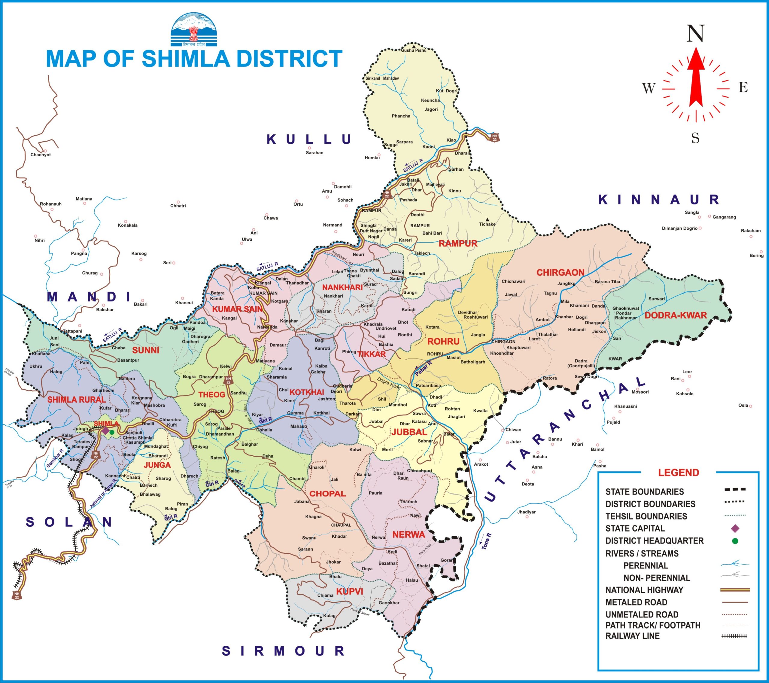
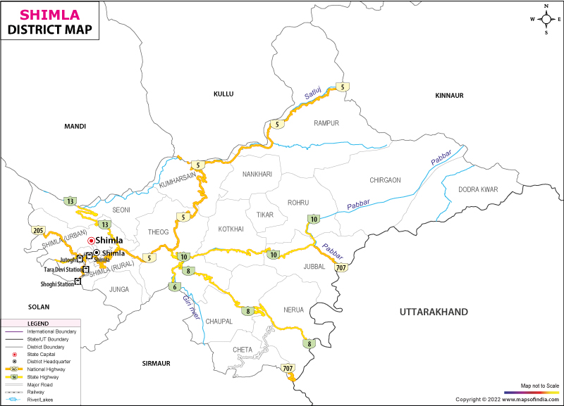
- Geographical Coordinates: Shimla District is situated between longitudes 76°59’22” and 78°18’40” east and latitudes 30°45’48” and 31°43’0” north.
- Boundaries: The district is bordered by Mandi and Kullu districts to the north, Kinnaur to the east, Uttarakhand and Sirmaur districts to the south, and Solan district to the west.
Elevation:
- Height: The elevation in Shimla District ranges from 300 meters to 6,000 meters above sea level.
Area:
- Total Area: The district covers an area of 5,131 square kilometers, which is part of the total area of 55,673 square kilometers of Himachal Pradesh.
Average Rainfall:
- Annual Rainfall: The average annual rainfall in Shimla District is 1,028 mm.
Major Peaks:
- Churdhar: Located in the Chaupal tehsil.
- Shali: Located in the Sunni tehsil.
- Jakhoo: Located in Shimla city.
- Siah: Located near Chail.
- Chanshal: Located in the Rohru tehsil.
- Hatu: Located in Kumharsain.
Shimla District: Rivers and Lakes
Rivers:
Sutlej River:
-
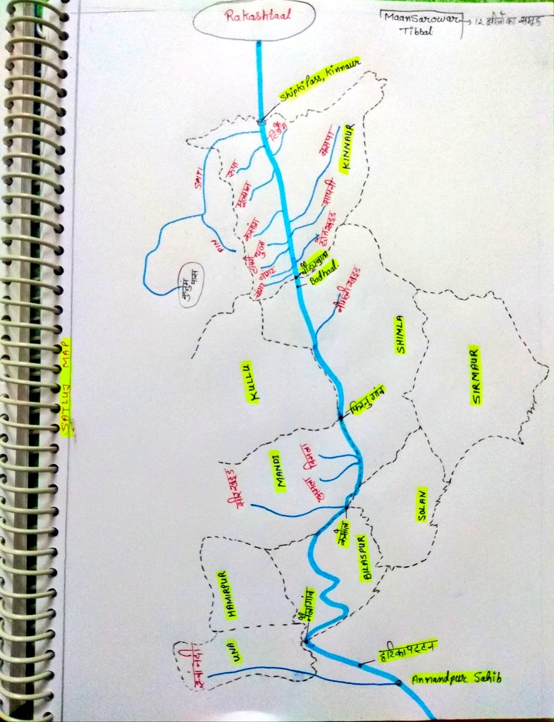
- Flow Area: The Sutlej River enters Shimla District at “Badhal” in the Rampur tehsil, flowing from the Kinnaur District.
- Boundary Formation: It forms the boundary with Kullu’s Nirmand and Ani tehsils, and Mandi’s Karsog tehsil.
- Source: Originates from the Sunni tehsil in Shimla District.
- Major Tributaries: Includes Nogli, Machhada, Bhaira, Kingal, Khekhar, Chamola, Savera, and Bagh nallahs.
-
Giri Ganga River:
- Source: Originates from the Kuppar peak.
- Major Tributary: Ashni (Ashwani Khad) is the main tributary.
- Flow: Collects water from Churdhar and Shimla ranges, merging with the river near Shimla city and flows southeast.
- Location: Shimla city is situated along this river.
-
Pabber River:
- Source: Originates from the base of the Chandernahan peak in Rohru tehsil.
- Flow Area: Flows through Rohru and Jubbal and merges into the Tons River in Uttarakhand.
- Major Tributaries: Includes Shikari, Andhra, Pejor, Hathkoti, etc.
Lakes:
1. Chandranahan or Chander Naun Lake:
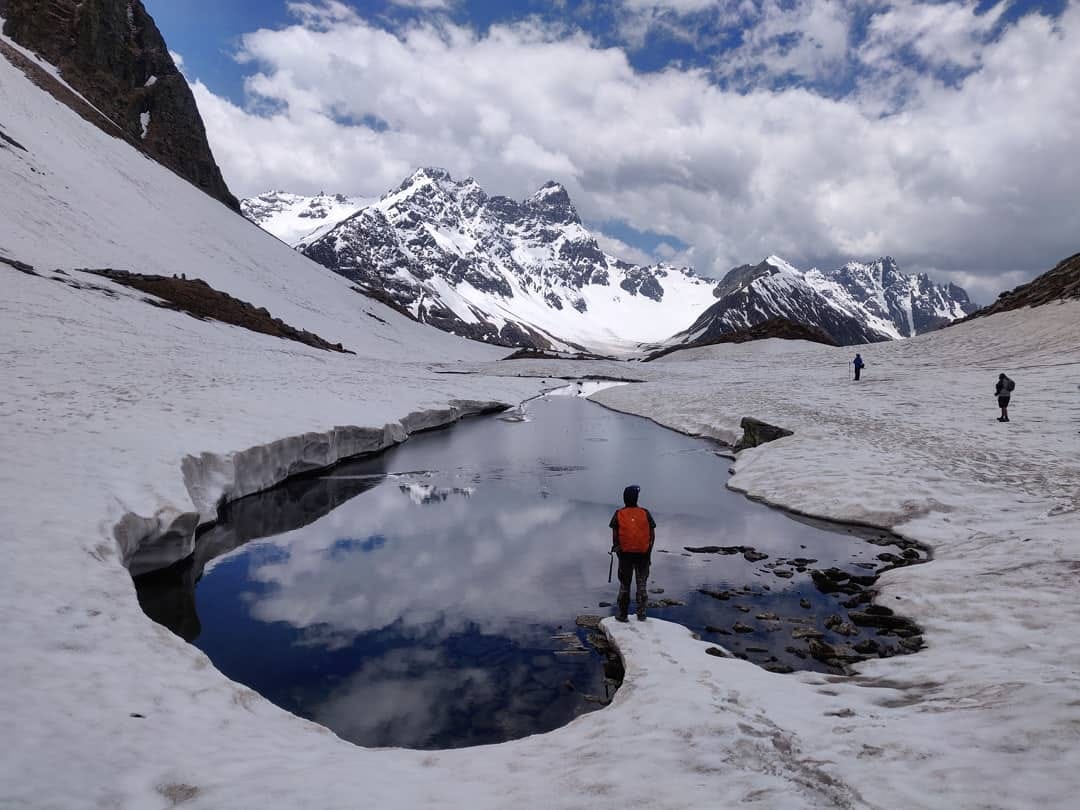
- Description: Located in the Chanshal range, Chandranahan Lake is accessible to experienced trekkers. The lake is fed by a series of springs and is surrounded by snow for long periods, serving as a pristine natural attraction.
- Location: Chanshal range, Himachal Pradesh.
- Activities: Trekking and nature exploration.
Description: Chandranahan Lake, also known as Chander Naun, is a high-altitude lake situated in the Chanshal range of the Shimla district, specifically in the Rohru tehsil. The lake, at an elevation of approximately 4,260 meters (13,976 feet) above sea level, is fed by a series of springs and is surrounded by snow for extended periods, making it a pristine and picturesque destination. It serves as the source of the Pabbar River.
Location:
- District: Shimla
- Tehsil: Rohru
- Elevation: 4,260 meters (13,976 feet)
2. Dhamwari Sundra Hydro Electric Project:
- Description: The Dhamwari Sundra Hydro Electric Project is a significant energy project in the Pabbar River Valley, contributing to the region’s power supply.
- Location: Pabbar River Valley, Himachal Pradesh.
- Activities: While primarily an industrial site, the area around may offer opportunities for sightseeing and understanding hydroelectric power.
Dhamwari Sundra Hydro Electric Project
Overview: The Dhamwari Sundra Hydro Electric Project is a significant hydroelectric power venture located in the Rohru area of Shimla district. It is designed to harness the potential of the Pabbar River, a tributary of the Yamuna River, for generating electricity.
Project Details:
- Capacity: 70 Megawatts
- Location: Rohru, Shimla district, Himachal Pradesh
- Construction Start Date: June 10, 2002
- Cost: ₹450 crores
- Implementing Agency: Dhamwari Power Company, with Hajara Engineering responsible for its completion
Key Features:
- Dam Construction: The project involves the construction of a diversion dam on the Pabbar River.
- Tunnel Length: A 10 km long tunnel is part of the infrastructure.
- Transmission: Generated electricity will be transmitted through a 132 kV transmission line to feed into the northern grid of Shimla.
- Employment Impact: The project is expected to create approximately 10,000 direct and indirect job opportunities.
Historical Background:
- The initial agreement for the project was made with M/s Dhamwari Power Company on October 17, 1996, but it was later cancelled. The revised project was officially launched with the foundation stone laying ceremony by then Chief Minister of Himachal Pradesh, Shri P.K. Dhumal, in Tikari village, 150 km from Shimla.
3. Karali Lake:
- Description: Karali Lake is a notable lake located on Chhota Shali hillock, near Shali Peak. It is known for its picturesque setting and is roughly the size of Annandale Ground.
- Location: Near Shali Peak, Shimla District.
- Activities: Nature walks, picnicking, and photography.
Location:
- Region: Shimla District, Himachal Pradesh
- Proximity: Located on the Chhota Shali hillock, opposite Shali Peak
Description: Karali Lake is a notable high-altitude lake situated in the Shimla district. It is positioned on the Chhota Shali hillock, just across from Shali Peak. The lake’s surface area is comparable to that of the Annadale ground in Shimla, making it a significant water body in the region.
Features:
- Size: The lake’s size is roughly equivalent to the Annadale ground.
- Appearance: Despite the water not being very clean, Karali Lake is striking from a distance. When viewed from a high vantage point, it appears to shine like a large emerald in the sunlight, nestled among the trees.
- Scenic Beauty: The location of Karali Lake is picturesque, offering stunning views and a serene environment that is worth visiting.
4. Pabbar River Lake:
- Description: Located in the Valley of the Pabbar River, this area is accessible from Theog and Rohru. It is known for trout fishing and scenic beauty.
- Location: Rohru, 131 km from Shimla.
- Activities: Trout fishing, sightseeing, and trekking.
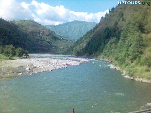
Pabbar Valley
Location:
- Region: Shimla District, Himachal Pradesh
- Main Town: Rohru (131 km from Shimla)
- Access: The valley is accessed from Theog on the Hindustan-Tibet Road.
Description: Pabbar Valley is a picturesque region situated in the Shimla district of Himachal Pradesh, known for its natural beauty and tranquil environment. It is a prominent location for those seeking offbeat travel experiences away from the usual tourist spots.
Features:
- Scenic Beauty: The valley is surrounded by lush apple orchards, dense forests of deodar and oak, and is set against the stunning backdrop of the Chanshal mountain range. The region offers breathtaking views and a serene atmosphere.
- Chanshal Pass: At an elevation of 4,220 meters (13,926 feet), the Chanshal Pass is a significant landmark in the valley. It remains accessible from May to October, providing a gateway to explore the higher altitudes.
- River Pabbar: The valley is named after the Pabbar River, which originates in the snow-capped mountains and is fed by glacial ice. The river meanders through the valley before joining the Tons River and ultimately feeding the Yamuna.
5. Rampur Hydro Electric Project:
- Description: This major hydroelectric project has a capacity of 400 megawatts and is a critical part of the region’s power infrastructure.
- Location: Rampur, Himachal Pradesh.
- Activities: Primarily an industrial site; however, nearby areas may offer scenic views and opportunities for exploring the local landscape.

Rampur Hydro Electric Project
The highly anticipated Rampur Hydro Electric Project, with a capacity of 400 megawatts, has been transferred to the Satluj Jal Vidyut Nigam (SJVN). The state government will retain a 30% stake in the project. The project’s resettlement and rehabilitation plan has also been approved. The implementation of the project will be based on a 30:70 equity participation ratio between the Himachal Pradesh government and SJVN.
6. Sawra Kundu Hydro Electric Project:
- Description: A 110-megawatt hydroelectric project situated on the Pabbar River, contributing to regional power needs.
- Location: Pabbar River Valley, Himachal Pradesh.
- Activities: Similar to other hydroelectric projects, it is mainly industrial, but surrounding areas may provide opportunities for sightseeing.

Sawra Kundu Hydro Electric Project
The Sawra Kundu Hydro Electric Project, with a capacity of 110 megawatts, is set to be constructed on the Pabbar River in the Hatkoti area of Jubbal tehsil in Shimla district. This project will be developed jointly by the Himachal Pradesh government and the Bhakra Beas Management Board (BBMB), which includes representatives from Himachal Pradesh, Haryana, Punjab, and Rajasthan. The decision to undertake the project was made during a joint meeting of these states on December 8, 2002.
7. Tani Jubber Lake:
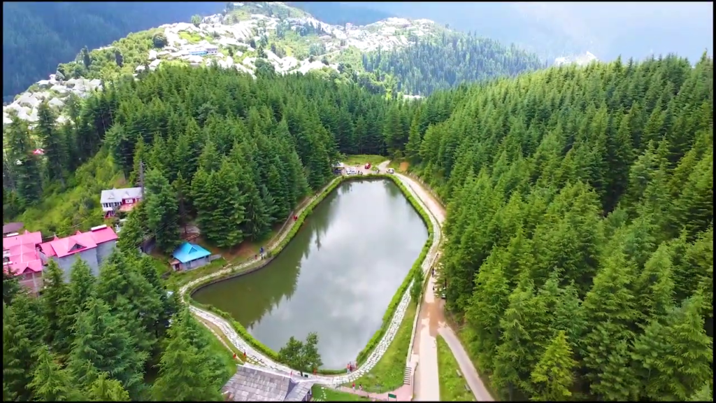
- Description: Tani Jubber Lake is a scenic lake surrounded by lush green slopes and apple orchards, with snow-covered mountains in the background. Located at Thanedar, it is known for its tranquil beauty.
- Location: Thanedar, Shimla District.
- Activities: Nature walks, photography, and relaxing in the natural surroundings.
- Tani Jubbar Lake
Shimla District: Geological Structure and Mineral Resources
Geological Structure:
-
The geological structure of Shimla District primarily consists of the Jutogh Group, with other formations including:
- Krol Series
- Nagtha Group
- Shimla Group
- Rampur-Banjar Structures
- Shali-Devban
- Unclassified Granites
-
Soil Types: Range from sandy to heavy clay soils. The deep valleys and basins typically have sandy and sandy loam soils.
-
Soil Classification by NBSS & LUP (ICAR), Nagpur:
- Predominantly Orthents – Acrapts.
- Eastern, southern, and western areas classified as Udalfs, Udalfs-Acrepts, and Acrapts-Orthents.
- Glacial and snow-covered soils are found in the northernmost part of the district.
-
Geological History: Approximately 1,200-1,500 million years ago, the area was part of the Tethys Sea.
Mineral Resources:
-
Limestone:
- Minerals: Includes limestone, quartzite, slate, barytes, lead, and barium.
- Commercial Importance: Limestone and slate are commercially significant; other minerals are not economically important.
-
Gold:
- Feature: Alluvial gold is commonly found in the rivers of the Himalayas.
- Location: Found near Urni, Chirrgaon (31° 32′: 78° 6′), but lacks economic significance.
-
Iron Ore:
- Location: Hematite iron ore is found in lens-shaped deposits in Rohru.
-
Iron-Pyrite:
- Location: Commonly found in the Kyanthal area and south of Shimla in lenticular bands within the Jutogh Series.
-
Kyanite:
- Location: Found abundantly in the schist and granite regions of the western Himalayas near the Bushahr area.
-
Slate:
- Location: Extracted from various locations in the outer Himalayas of Shimla Hills.
-
Other Minerals: Includes barites, lead, and barytes.
Additional Information:
- Dialect: People from the Bushahr region (mainly Kinnaur and Kotkhai areas) speak the Kochi dialect.
This detailed description provides an overview of Shimla District’s geographical, geological, and mineral resources.
- Shimla was originally built on seven hills: Inverarm Hill, Observatory Hill, Prospect Hill, Summer Hill, Bantony Hill, Elysium Hill, and Jakhu Hill. Jakhu Hill, the highest point in Shimla at 2,454 meters (8,051 feet), remains a prominent landmark. In recent times, the city has expanded beyond these initial seven hills.
Climate:
-
Climate Classification: Shimla features a subtropical highland climate (Cwb) according to the Köppen climate classification. Winters are cool and summers are moderately warm.
-
Temperature:
- Summer: Average temperatures range from 16°C to 25°C (61°F to 77°F).
- Winter: Average temperatures range from 3°C to 11°C (37°F to 52°F).
-
Precipitation:
- Monthly Variation: Precipitation ranges from 13.6 millimeters (0.54 inches) in November to 350 millimeters (14 inches) in August. Winter and spring months generally receive around 45 millimeters (1.8 inches) of rain per month, while June sees about 190 millimeters (7.5 inches) as the monsoon begins.
- Annual Total: Average annual precipitation is 1,487 millimeters (59 inches), which is relatively less compared to other hill stations but still substantial compared to plains.
-
Snowfall: Historically, snowfall has occurred in December but has recently shifted to January or early February. The highest recorded snowfall was 38.6 centimeters (15.2 inches) on January 18, 2013, with a total of 63.6 centimeters (25.0 inches) over two days (January 17-18, 2013).
-
Extreme Temperatures:
- Highest Recorded Temperature: 32.4°C (90.3°F) on May 28, 2010.
- Lowest Recorded Temperature: -12.2°C (10.0°F) on December 13, 1963.
-
Recent Weather Events: On August 12-13, 2023, torrential rains linked to climate change caused severe landslides in Shimla, resulting in the deaths of at least 57 people, part of the broader 2023 North India floods.
Places of Interest in Shimla
1. The Mall:
- Description: The Mall is the main shopping street in Shimla, featuring a variety of restaurants, clubs, banks, bars, post offices, and tourist offices. It is a central location for visitors and locals alike.
- Notable Buildings: The lower part of Gaiety Theatre, which is a historic theater and cultural landmark.
2. The Ridge:
- Description: The Ridge is a large open space adjacent to The Mall, serving as a venue for cultural activities and events.
- Notable Sites: Christ Church, the second oldest church in Northern India, known for its stained glass windows depicting faith, hope, charity, fortitude, patience, and humility. Also located here are the State Library and the Gaiety Heritage Cultural Complex.
3. Jakhoo Hill:
- Description: Jakhoo Hill is the highest peak in Shimla, offering panoramic views of the city and the surrounding snow-covered Himalayas. The Jakhoo Temple, dedicated to Hanuman, is a popular site. The hill features a 108-foot statue of Hanuman, which is one of the highest-altitude statues in the world.
- Ropeway: Jakhoo Hill has the first ropeway in Shimla, connecting Jakhoo Temple to The Ridge.
4. Kali Bari Temple:
- Description: Dedicated to Goddess Kali, this temple is the namesake of Shimla (originally named after Shyamala, a form of Kali). It offers extensive views of Annadale, Shimla Railway Station, and other landmarks.
5. Annadale:
- Description: Located 2-4 km from The Ridge, Annadale was originally developed as a racecourse. It now hosts the Army Heritage Museum, a golf course, and a helipad. It has been a key site for VIP arrivals in Shimla and hosted the first Durand Cup Football Tournament in 1888.
6. Indian Institute of Advanced Studies:
- Description: Housed in the former Viceregal Lodge (built 1884–88), this institute is a center for advanced research and studies.
7. Himachal Pradesh State Museum:
- Description: Opened in 1974, this museum showcases the cultural heritage of Himachal Pradesh with exhibits of miniature Pahari paintings, sculptures, bronzes, wood carvings, costumes, textiles, and jewelry.
8. Summer Hill:
- Description: Situated at a height of 6,500 feet, Summer Hill is part of the Shimla-Kalka railway line. It is known for its quiet surroundings and was a residence of Mahatma Gandhi during his visits to Shimla. Himachal Pradesh University is also located here.
9. Sankat Mochan Temple:
- Description: Located on the Shimla-Chandigarh highway, this temple is dedicated to Hanuman and is a popular pilgrimage site.
10. Tara Devi Temple:
- Description: Situated 11 km from Shimla’s bus stand, this temple is dedicated to the goddess of stars. The area also hosts the Bharat Scouts and Guides headquarters.
11. Sanjauli:
- Description: A suburb of Shimla, Sanjauli features the Dhingu Mata Temple, located atop a hill. It is the second-highest hilltop temple in Shimla after Jakhoo Temple.
12. Kamna Devi Temple:
- Description: Located on Prospect Hill in Baileuganj, this temple is dedicated to Kamna Devi and offers scenic views.
13. Chadwick Falls:
- Description: A picturesque waterfall located a short distance from Shimla, known for its natural beauty.
14. Kufri:
- Description: Situated near Shimla, Kufri is known for its annual winter sports festival in February, as well as activities like skiing and tobogganing.
15. Himalayan Nature Park:
- Description: Located just outside Shimla, this park is dedicated to the region’s flora and fauna.
16. Chharabra:
- Description: Located near Kufri, Chharabra is noted for its natural beauty and the Kalyani helipad.
17. Mashobra:
- Description: Near Shimla, Mashobra features Craignano Park, a popular spot for visitors.
18. Jutogh:
- Description: Located 8 km from Shimla city center, Jutogh is an army cantonment near Totu, an important suburb of Shimla.
Each of these locations offers unique experiences, from cultural and historical sites to natural beauty and recreational activities.
शिमला जिला: भूगोल और प्रमुख विशेषताएँ
स्थान और सीमा:
- भौगोलिक निर्देशांक: शिमला जिला 76°59’22” और 78°18’40” पूर्व देशांतर और 30°45’48” और 31°43’0” उत्तर अक्षांश के बीच स्थित है।
- सीमाएँ: उत्तर में मंडी और कुल्लू जिले, पूर्व में किन्नौर, दक्षिण में उत्तराखंड राज्य और सिरमौर जिले, और पश्चिम में सोलन जिले से घिरा है।
ऊंचाई:
- उच्चता: जिले की ऊंचाई 300 मीटर से लेकर 6,000 मीटर तक है।
क्षेत्रफल:
- कुल क्षेत्रफल: शिमला जिले का क्षेत्रफल 5,131 वर्ग किलोमीटर है। हिमाचल प्रदेश के कुल 55,673 वर्ग किलोमीटर क्षेत्रफल में से यह जिले का हिस्सा है।
औसत वर्षा:
- वार्षिक वर्षा: शिमला जिले की औसत वर्षा 1,028 मिमी है।
प्रमुख चोटियाँ:
- चूड़धार: चौपाल तहसील में स्थित, यह शिमला जिले की एक प्रमुख चोटी है।
- शाली: सुन्नी तहसील में स्थित।
- जाखू: शिमला शहर में स्थित।
- सियाह: चैल के निकट स्थित।
- चांसल: रोहड़ू तहसील में स्थित।
- हाटू: कुम्हारसैन में स्थित।
शिमला जिला: नदियाँ और झीलें
नदियाँ:
- सतलुज नदी:
- प्रवाहित क्षेत्र: सतलुज नदी किन्नौर जिले से होकर बहने के बाद रामपुर तहसील के “बधाल” स्थान पर शिमला जिले में प्रवेश करती है।
- सीमा निर्माण: सतलुज नदी कुल्लू की निरमंड और आनी तहसील और मंडी जिले की करसोग तहसील के साथ शिमला जिले की सीमा बनाती है।
- उत्पत्ति: यह नदी शिमला जिले के सुन्नी तहसील से निकलती है।
- मुख्य सहायक नदियाँ: नोगली, मछड़ा, भैरा, किंगल, खेखर, चमोला, सवेरा और बाग नाले आदि।
- गिरि गंगा नदी:
- उत्पत्ति: यह कुपार शिखर से निकलती है।
- मुख्य सहायक नदी: अशनि (अश्वनी खड्ड) गिरि नदी की मुख्य सहायक नदी है।
- जल-प्रवाह: यह नदी चूड़धार और शिमला पर्वतमाला के सम्पूर्ण भूभाग के जल-प्रवाह को एकत्रित करती है।
- जलधारा: गिरि नदी की मुख्य जलधारा अशनि खड्ड है, जो शिमला पर्वतमाला में महासू के निकट से निकलती है। शिमला शहर के पूर्वी मुख से जल प्राप्त करने के बाद गिरि नदी से मिल जाती है और दक्षिण-पूर्व की ओर मुड़ जाती है।
- स्थान: शिमला शहर इसी नदी पर बसा है।
- पब्बर नदी:
- उत्पत्ति: यह रोहड़ू तहसील में चंद्रनहन चोटी के आधार से निकलती है।
- प्रवाहित क्षेत्र: यह नदी रोहड़ू और जुब्बल से होकर बहती है और उत्तराखंड में त्यूनी में टोंस नदी में मिल जाती है।
- मुख्य सहायक नदियाँ: शिकरी, आंध्रा, पेजोर, हथकोटी आदि।
झीलें:
- तानी जुब्बार झील
- चंद्रनहन झील
- कराली झील
इस जानकारी से शिमला जिले की प्रमुख नदियाँ और झीलें स्पष्ट रूप से दर्शाई गई हैं, जो क्षेत्र की जलवायु और भौगोलिक विशेषताओं को उजागर करती हैं।
शिमला की भूवैज्ञानिक संरचना और खनिज संसाधन
भूवैज्ञानिक संरचना:
शिमला जिले की भूवैज्ञानिक संरचना मुख्य रूप से जुटोघ समूह से बनी है। हालांकि, जिले में अन्य भूवैज्ञानिक संरचनाएँ भी देखी जाती हैं, जिनमें शामिल हैं:
- क्रोल श्रृंखला
- नागथा समूह
- शिमला समूह
- रामपुर-बंजार संरचनाएँ
- शाली-देवबन
- ग्रेनाइट्स (अवर्गीकृत)
मिट्टी की बनावट में हल्की रेतीली से लेकर भारी चिकनी मिट्टी तक विविधता देखने को मिलती है। गहरी घाटियों और बेसिनों में, मिट्टी आमतौर पर रेतीली और रेतीली दोमट होती है।
एनबीएसएस और एलयूपी (आईसीएआर) नागपुर द्वारा वर्गीकृत जिले की मिट्टी मुख्य रूप से ऑर्थेंट्स – ऑक्रेप्ट्स प्रकार की है। हालांकि, पूर्वी, दक्षिणी और पश्चिमी छोर पर, मिट्टी को उदाल्फ़्स, उदाल्फ़्स-ऑर्केप्ट्स और ऑर्केप्ट्स-ऑर्थेंट्स के रूप में वर्गीकृत किया गया है। जिले के सुदूर उत्तरी भाग में ग्लेशियर और बर्फ से ढकी मिट्टी पाई जाती है।
भूविज्ञान के अध्ययन के अनुसार, लगभग 1,200-1,500 मिलियन वर्ष पहले वर्तमान शिमला जिले में शामिल क्षेत्र टेथिस नामक समुद्र का एक हिस्सा था।
खनिज संसाधन:
- अलम्प:
- खनिज: चूना पत्थर, क्वार्टजाइट, स्लैब, बेराइट्स, सीसा और बायराइट
- वाणिज्यिक महत्व: चूना पत्थर और स्लैब स्लेट को छोड़कर अन्य खनिज व्यावसायिक महत्व के नहीं हैं।
- सोना:
- विशेषता: हिमालय की नदियों में जलोढ़ सोना आम विशेषता है।
- स्थान: उरनी के पास चिरगांव (31° 32′: 78° 6′) में पाया जाता है, लेकिन इसका आर्थिक महत्व नहीं है।
- लौह अयस्क:
- स्थान: धारीदार तथा लेंसनुमा हेमेटाइट लौह अयस्क रोहड़ू में पाया जाता है।
- लौह-पाइराइट:
- स्थान: क्योंथल क्षेत्र में और शिमला के दक्षिण में, लौह पाइराइट के सामान्य लेंटिकुलर बैंड जुटोग श्रृंखला के बायो-लीगुंगे चरण के स्लेट पाए जाते हैं।
- स्थान:
- क्यारी (शामरी) नाला
- बढईघाट
- रेहाना के उत्तर में
- छोटा शिमला के दक्षिण में
- चायनाइट:
- स्थान: पश्चिमी हिमालय में बुशहर के कुछ भागों के पास शिस्ट और ग्रेनाइट में प्रचुर मात्रा में पाया जाता है।
- चूना पत्थर:
- स्थान: जिले के नालदेहरा और बसंतपुर में चूना पत्थर के भंडार पाए गए हैं। इनमें से कुछ भंडार सीमेंट ग्रेड के हो सकते हैं।
- स्लेट:
- स्थान: शिमला हिल्स के बाहरी हिमालय में कई स्थानों पर इनका उत्खनन किया जाता है।
अन्य सूचना:
- बुशहर (मुख्यतः किन्नौर और कोटगढ़ क्षेत्र) के लोग कोच्चि बोली बोलते हैं।
इस विवरण से शिमला जिले की भूवैज्ञानिक संरचना और खनिज संसाधनों के बारे में विस्तृत जानकारी प्राप्त होती है।
Index
Q1. What is the primary purpose of the Chandranahan or Chander Naun Lake?
A. Agricultural irrigation
B. Hydroelectric power generation
C. Source of the river Pabbar
D. Tourist attraction
Answer: C. Source of the river Pabbar
Explanation: Chandranahan Lake, located in the Chanshal range, is the source of the river Pabbar.
Q2. Which lake is located about 45 km from Chamba town and is held sacred to Lord Shiva?
A. Karali Lake
B. Tani Jubber Lake
C. Lama Dal
D. Chander Naun Lake
Answer: C. Lama Dal
Explanation: Lama Dal is a high-altitude lake located about 45 km from Chamba town and is sacred to Lord Shiva.
Q3. What is the surface elevation of Chander Naun Lake?
A. 3,500 meters
B. 4,000 meters
C. 4,260 meters
D. 5,000 meters
Answer: C. 4,260 meters
Explanation: Chander Naun Lake is situated at an elevation of 4,260 meters above sea level.
Q4. Which river does the Pabbar Valley eventually join?
A. Yamuna
B. Ganges
C. Sutlej
D. Ravi
Answer: A. Yamuna
Explanation: The Pabbar River eventually joins the Tons River, which feeds into the Yamuna.
Q5. What is the primary function of the Dhamwari Sundra Hydro Electric Project?
A. Irrigation
B. Water supply
C. Electricity generation
D. Flood control
Answer: C. Electricity generation
Explanation: The Dhamwari Sundra Hydro Electric Project is designed for generating electricity.
Q6. When did the foundation stone for the Dhamwari Sundra Hydro Electric Project get laid?
A. June 10, 2002
B. July 15, 2001
C. August 22, 2000
D. September 30, 2003
Answer: A. June 10, 2002
Explanation: The foundation stone for the Dhamwari Sundra Hydro Electric Project was laid on June 10, 2002.
Q7. Which company is responsible for the implementation of the Dhamwari Sundra Hydro Electric Project?
A. Himachal Pradesh State Electricity Board
B. Dhamwari Power Company
C. Satluj Jal Vidyut Nigam
D. Bhakra Beas Management Board
Answer: C. Satluj Jal Vidyut Nigam
Explanation: The Dhamwari Sundra Hydro Electric Project is being implemented by Satluj Jal Vidyut Nigam.
Q8. How much equity will the Himachal Pradesh government hold in the Ramapur Hydro Electric Project?
A. 25%
B. 30%
C. 50%
D. 70%
Answer: B. 30%
Explanation: The Himachal Pradesh government will hold a 30% equity stake in the Ramapur Hydro Electric Project.
Q9. What is the power generation capacity of the Rampur Hydro Electric Project?
A. 150 MW
B. 200 MW
C. 300 MW
D. 400 MW
Answer: D. 400 MW
Explanation: The Rampur Hydro Electric Project has a generation capacity of 400 megawatts.
Q10. What is the location of the Karali Lake?
A. Near Shimla
B. In the Chanshal range
C. On the Chhota Shali hillock
D. In the Pabbar Valley
Answer: C. On the Chhota Shali hillock
Explanation: Karali Lake is located on the Chhota Shali hillock, just on the other side of Shali peak.
Q11. Which project will the Sawra Kundu Hydro Electric Project involve construction on?
A. Yamuna River
B. Sutlej River
C. Pabbar River
D. Beas River
Answer: C. Pabbar River
Explanation: The Sawra Kundu Hydro Electric Project will be constructed on the Pabbar River.
Q12. Which temple is located near Shimla and dedicated to Goddess Kali?
A. Jakhoo Temple
B. Kali Bari Temple
C. Sankat Mochan Temple
D. Tara Devi Temple
Answer: B. Kali Bari Temple
Explanation: The Kali Bari Temple is dedicated to Goddess Kali and is located near Shimla.
Q13. What is the primary focus of the Pabbar Valley?
A. Tourism
B. Apple orchards
C. Mining
D. Urban development
Answer: B. Apple orchards
Explanation: The Pabbar Valley is known for its prosperous apple orchards.
Q14. Which lake is known for its emerald-like appearance when viewed from afar?
A. Tani Jubber Lake
B. Karali Lake
C. Chander Naun Lake
D. Lama Dal
Answer: B. Karali Lake
Explanation: Karali Lake is noted for its emerald-like appearance when viewed from a distance.
Q15. In which district is the Chander Naun Lake located?
A. Chamba
B. Kinnaur
C. Shimla
D. Solan
Answer: C. Shimla
Explanation: The Chander Naun Lake is located in the Shimla district.
Q16. What is the primary use of the Pabbar River?
A. Drinking water
B. Industrial use
C. Trout fishing
D. Hydroelectric power
Answer: C. Trout fishing
Explanation: The Pabbar River is a good location for trout fishing.
Q17. What is the size of the Karali Lake compared to the Annadale ground in Shimla?
A. Smaller
B. Larger
C. Equal
D. Double
Answer: C. Equal
Explanation: The size of Karali Lake is almost equal to the size of the Annadale ground.
Q18. What elevation does the Chanshal Pass reach?
A. 3,000 meters
B. 4,000 meters
C. 4,220 meters
D. 4,200 meters
Answer: C. 4,220 meters
Explanation: The Chanshal Pass reaches an elevation of 4,220 meters.
Q19. Which river’s tributaries are mentioned in the context of Pabbar Valley?
A. Sutlej
B. Yamuna
C. Beas
D. Ravi
Answer: B. Yamuna
Explanation: The Pabbar River feeds into the Tons River, which ultimately joins the Yamuna.
Q20. Which fair is celebrated in Rohru and features Natti dances and cultural activities?
A. Lavi Fair
B. Bhoj Fair
C. Mahasu Jatar
D. Pathar-Ka-Khel-Halog
Answer: C. Mahasu Jatar
Explanation: The Mahasu Jatar is celebrated in Rohru and includes Natti dances and cultural activities.
Also Read This:
-
Geography of Lahaul
Explore the unique geography of Lahaul, including its terrain, climate, and key features that shape this remote region of Himachal Pradesh. -
Geography of Mandi
Delve into the geographical aspects of Mandi District, highlighting its landscape, river systems, and climatic conditions. -
River System in Himachal Pradesh
Understand the river systems of Himachal Pradesh, including major rivers, their sources, and their impact on the region’s geography. -
Lakes of Himachal Pradesh
Discover the picturesque lakes of Himachal Pradesh, their locations, and their significance to the local ecosystem and tourism. -
Geography of Chamba
Learn about the geographical features of Chamba District, including its topography, climate, and natural landmarks. -
Kullu District
Gain insights into the geography of Kullu District, focusing on its valleys, rivers, and climate that influence its landscape. -
Kinnaur District
Explore the diverse geography of Kinnaur District, including its mountainous terrain, river systems, and climatic variations.